Borders and Districts of Galicia
Galicia as a geopolitical entity was created in 1772 with the establishment of the Kingdom of Galicia and Lodomeria, the Habsburg Monarchy’s (later the Austrian Empire’s) easternmost crownland. The capital of the province was Lemberg (today Lviv). A century and a half later, in 1918, Galicia was wiped from the world’s maps, with the fall of the Austro-Hungarian Empire.
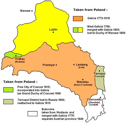
The borders of Galicia changed throughout the years. In 1795, in the Third Partition of Poland, West Galicia (also called New Galicia), which included the districts of Kraków, Lublin, Chełm, was created and merged with Galicia in 1803. These districts, along with a small sliver of the original Galicia, including the district of Zamość, were annexed to the Grand Duchy of Warsaw in 1809. Later, West Galicia referred to only the territory just west of Jarosław through the territory around Kraków.
The regions of Tarnopol (Ternopil) were included in the original formation of Galicia, but in 1809 they were ceded to the Russian Empire. During the Congress of Vienna (1814–1815), Austria gained back these regions.
In 1815, Kraków gained the status of a free city (The Free City of Cracow) and remained so until after the Polish uprising of 1846, when it was incorporated into Galicia as the Grand Duchy of Cracow.
Bukovina was formally annexed to the Austrian Empire in 1775 as part of Galicia. In 1849, Bukovina became a separate Austrian crownland, with its capital at Czernowitz (Chernivtsi).
Map Resources
The Polish digital library Polona has a wonderful collection of high-resolution zoomable maps of Galicia.
The website Topographic Maps of Eastern Europe, which offers a collection of small and large scale historical maps of the lands of the former Polish-Lithuanian Commonwealth and the Pale of Jewish Settlement in late Tsarist Russia, has a page devoted Galicia.
The Gesher Galicia Map Room, a long-term research project to acquire and publish land and building records in the former Austro-Hungarian province of Galicia, in addition to an extensive collection of cadastral and street maps, has a number of regional Galicia maps.
Historic Maps of Galicia
Below is a collection of different types of historic maps of Galicia spanning from 1775 (the oldest map of Galicia I found, made just a few years after the creation of the crownland) through 1918, the year Galicia ceased to exist as administrative unit.
- Lubomeriae et Galliciae Regni Tabula Geographica (1775)
- Carte nouvelle des Royaumes de Galizie et Lodomerie avec le District de Bukowine (1780)
- Spezial Karte von des Koenigreichs Galizien und Lodomerien: westlichen Kreisen (1789)
- General Charte des Atlasses von Galizien und Lodomerien (1790)
- Ost und West Galizien nach den neuesten beobachtungen (1805)
- Strassenkarte von Galizien (1820)
- Das Koenigreich Galizien (1832)
- Regno di Galizia e Lodomiria (1833)
- Karte des Konigreiches Galizien (1846)
- Das Koenigreich Galizien (1849)
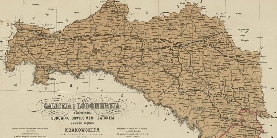
- Galicyja i Lodomeryja z ksiestwami Bukowina, Oswiecimem, Zatorem i wielkiem ksiestwem Krakowskiem dla użytku szkół ludowych (1872)
- Mapa Królestwa Galicyi do nauki z poglądu (1874)
- Mapa statystyczna Galicji i Bukowiny obejmująca stosunki ogólne polityczno-administracyjne, komunikacyjne, rolnicze a poszczególnie przemysł krajowy (1878)
- Map of Galicia and Bukovina in Hebrew (1878)
- General Post- und Strassenkarte von Galizien und Lodomerien mit Auschwitz, Zator und Krakau so wie des Kronlandes Bukowina (1893)
- Mapa ścienna Królestwa Galicyi i Lodomeryi z Wielkiem Księstwem Krakowskiem z Księstw: Oświęcimskiem i Zatorskiem (1894)
- Karta klimatyczna Galicyi (1899)
- Mapa Galicyi (1900)
- General Post- und Strassenkarte von Galizien und Lodomerien mit Auschwitz, Zator und Krakau (1900)
- Mapa ścienna Królestwa Galicyi i Lodomeryi z Wielkiem Księstwem Krakowskiem z Księstw: Oświęcimskiem i Zatorskiem (c. 1910)
- Galicja Map Językówa (1911)
- Mapa Galicyi i Bukowiny z Wielkim Księstwem Krakowskiem (1915)
- Galicya (1918)
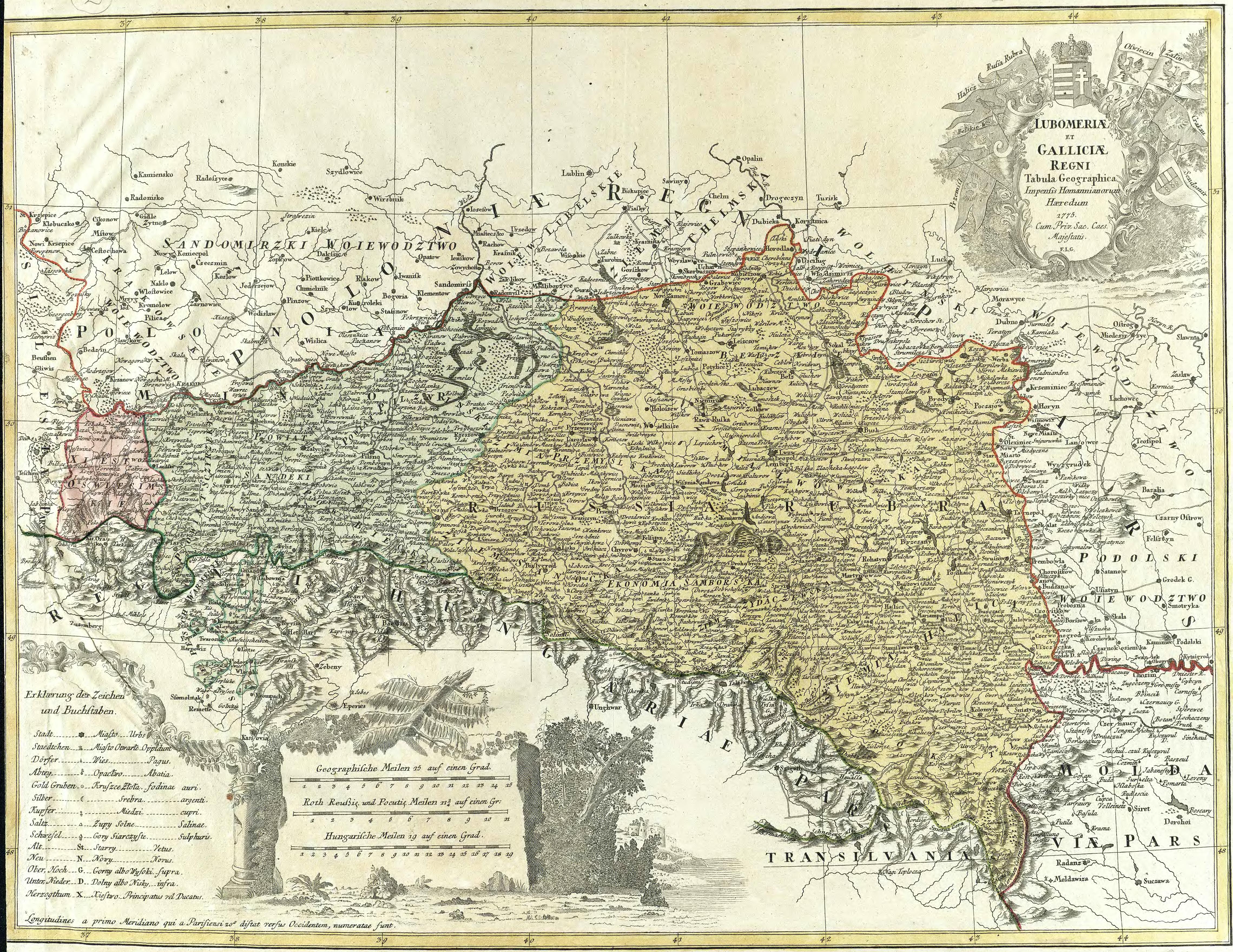
Lubomeriae et Galliciae Regni Tabula Geographica (1775)
F.L. Gussefeld, Nuremberg
Map of the Kingdoms of Lodomeria and Galicia. The map uses a mix of Latin, German, and Polish languages. Lviv is marked as Lwow, Leopol, and Lemberg. The the upper right corner has a decorative title cartouche with banners depicting the flags of the regions Przemysl, Belskie [Belz], Halics [Halisch], Rotrußland, Auschwitz, Zator, Krakau, Sandomir.
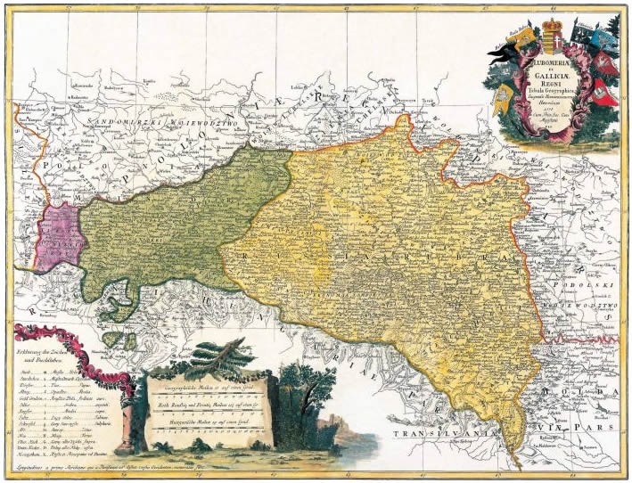
Full file view (download)
Source: RCIN
Carte nouvelle des Royaumes de Galizie et Lodomerie avec le District de Bukowine (1780)
T.C. Lotter, Augsburg
A New Map of the Kingdoms of Galicia and Lodomeria with the District of Bukovina. Fortified cities, villages, towns, hamlets, post routes, and post offices are marked on the map, with a French key to the symbols.
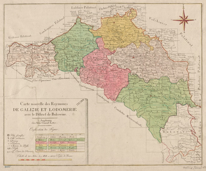
Original digital size can be found here.
Spezial Karte von des Koenigreichs Galizien und Lodomerien: westlichen Kreisen (1789)
Anton Friedrich Büsching, Franz Johann Joseph von Reilly, Vienna
Special map of the Kingdom of Galicia and Lodomeria: Western districts
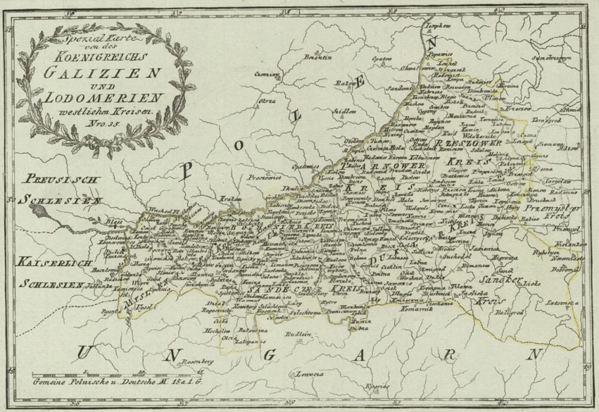
Zoom viewer: Polona
General Charte des Atlasses von Galizien und Lodomerien (1790)
F.I. Marie, Vienna
Map of Galicia and Lodomeria. Map is in French and German. The Zamość region, at the uppermost center of the map, is included in this early configuration of Galicia.
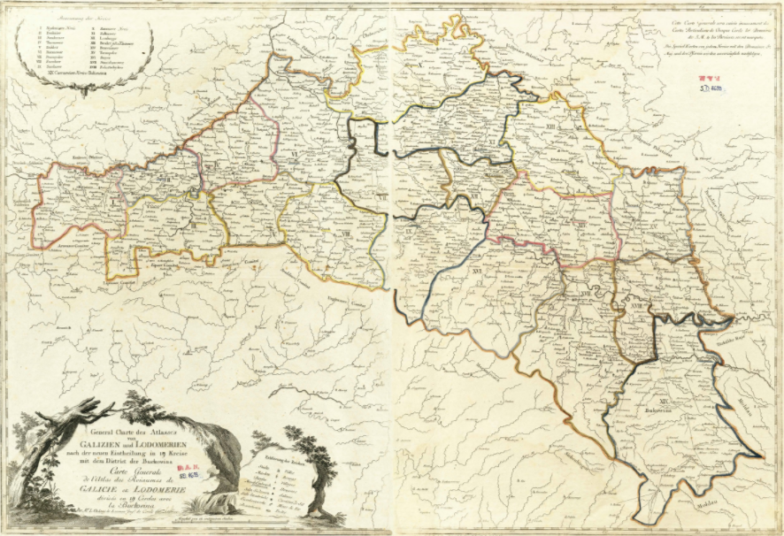
Full file view (download)
Source: RCIN
Ost und West Galizien nach den neuesten beobachtungen (1805)
Franz Reisser, Vienna
East and West Galicia according to the Latest Observations. Map is in German. “A partly-colored administrative map of (East) Galicia and the short-lived Austrian province of West Galicia (including Lublin and Radom), made just after the merger of the Two Galicias and a few years before West Galicia was lost to the Duchy of Warsaw…the map shows political boundaries, ranks towns by three size symbols, identifies, diocese seats for four kinds of Christian religions, and shows rivers and roads plus mines for salt, iron, lead, and silver.”
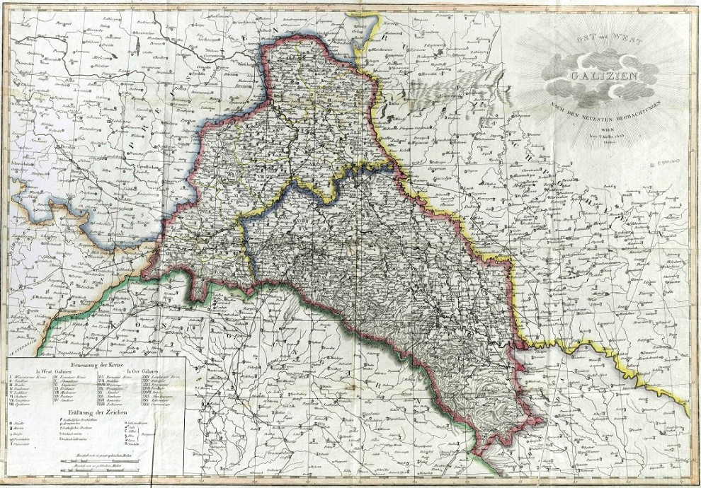
Source: Gesher Galicia
Strassenkarte von Galizien (1820)
Johann Blaim
Road Map of Galicia. From the Imperial and Royal Galician Roads and Bridge Construction Direction. Galicia no longer includes the northern districts of the original West Galicia, which were lost to the Grand Duchy of Warsaw in 1809.
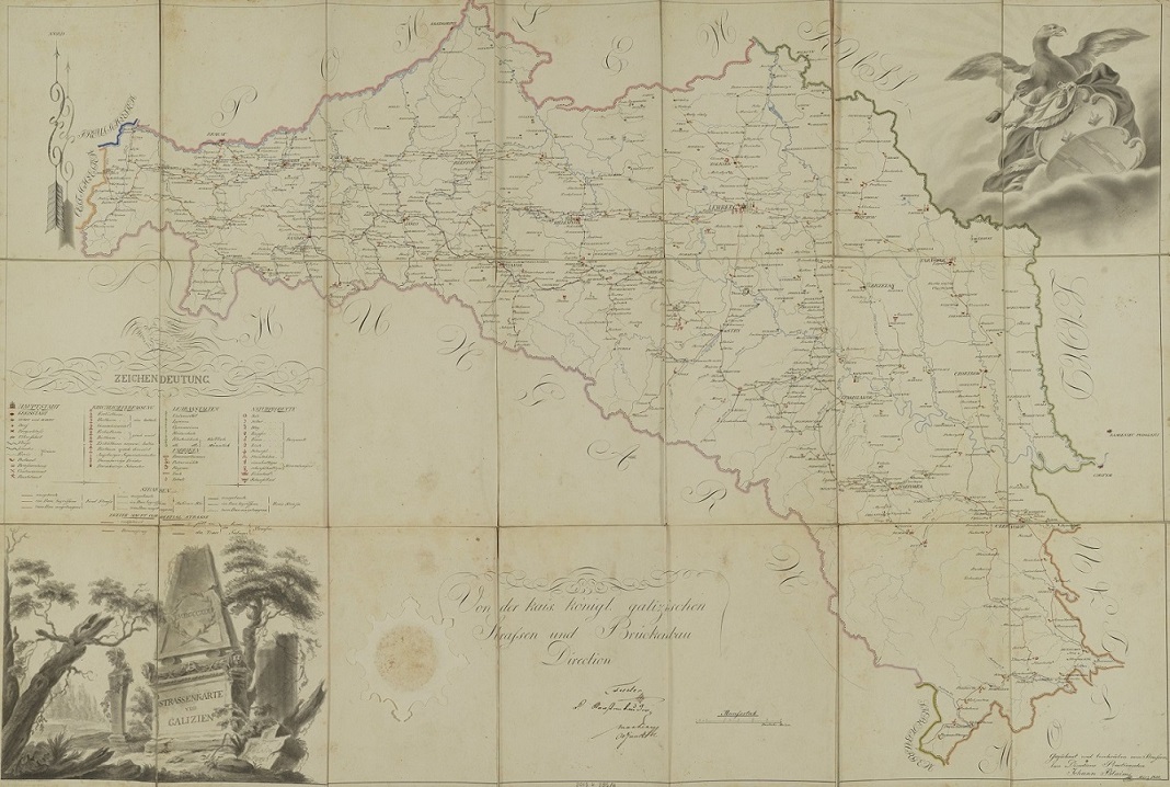
Zoom viewer: Polona
Das Koenigreich Galizien (1832)
C.F. Weiland
The Kingdom of Galicia
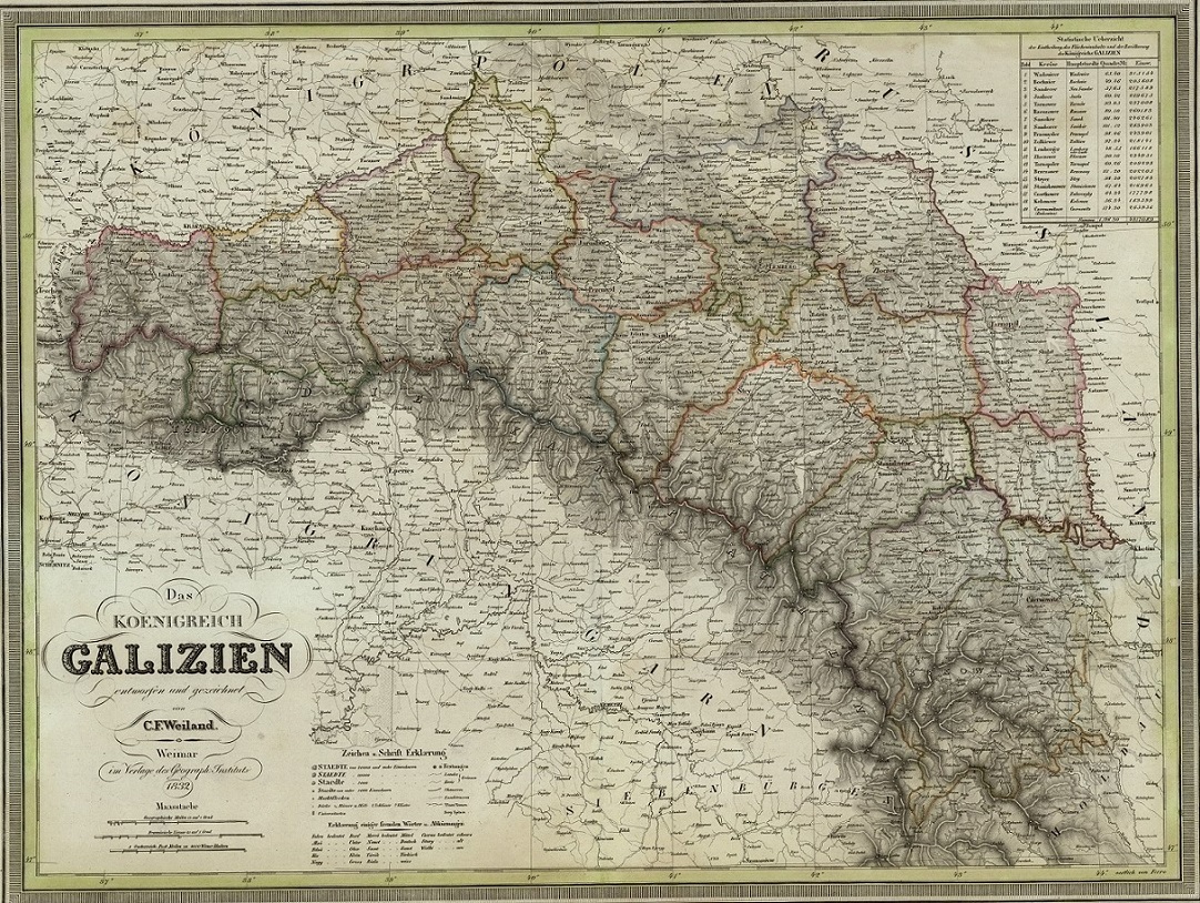
Full file view (download)
Source: RCIN
Regno di Galizia e Lodomiria (1833)
Giovanni Marieni
The Kingdom of Galicia and Lodomeria. Map is in Italian. Contains a table of political divisions.
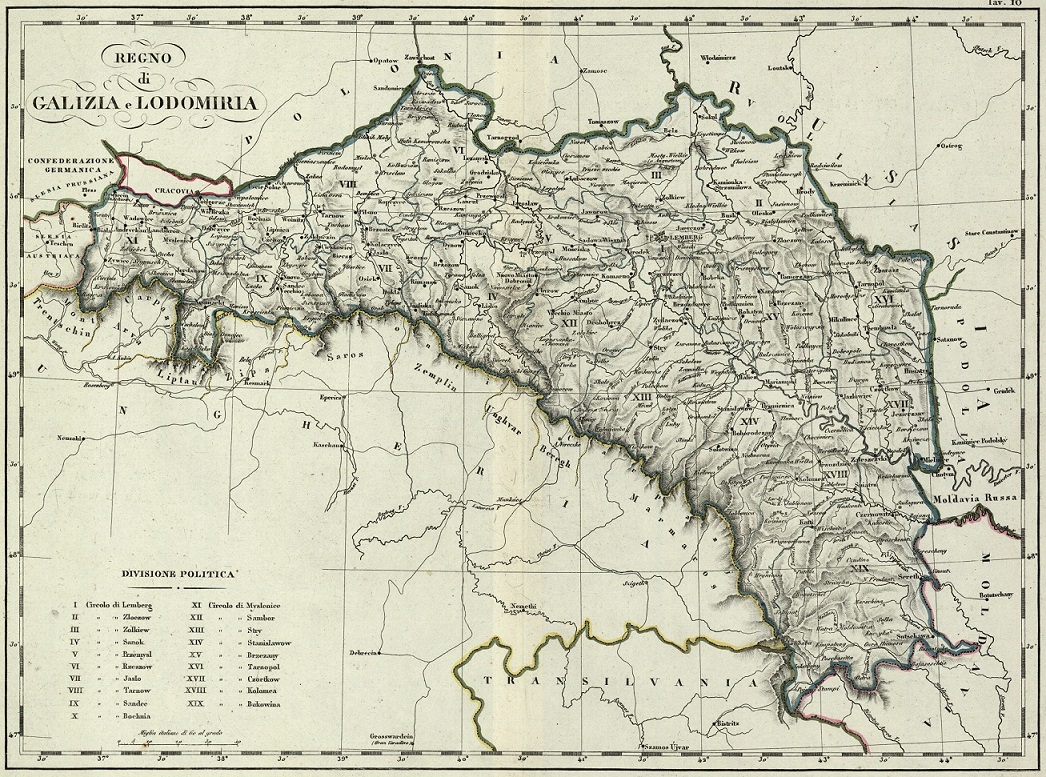
Zoom viewer: Polona
Karte des Konigreiches Galizien (1846)
F. Raffelsperger
Map of the Kingdom of Galicia. The Carpathian mountain range is shaded in with green hachures.
Full file view (download)
Source: http://rcin.org.pl/dlibra/docmetadata?id=370
Das Koenigreich Galizien (1849)
Carl Ferdinand Weiland
The Kingdom of Galicia. Shows Ost Galizien (East Galicia – Ruthenian or Lviv Gubernium) and West Galizien (West Galicia – Polish or Krakow Gubernium). (West Galicia is now much smaller than the original West (New) Galicia, having lost its northern districts in 1809, and now the new east-west border is farther east (Rzeszów, Tarnow, and Jaslo/Dukla regions now part of West Galicia) – see map from 1805.)
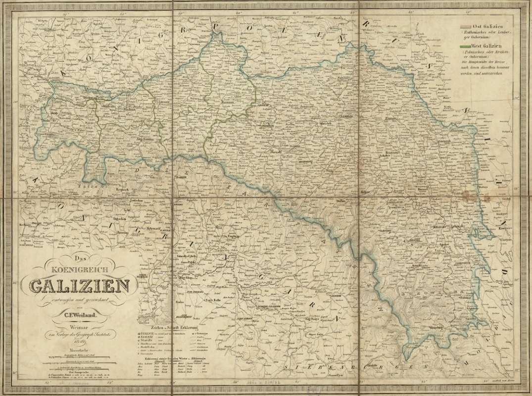
Zoom viewer: Polona
Galicyja i Lodomeryja z ksiestwami Bukowina, Oswiecimem, Zatorem i wielkiem ksiestwem Krakowskiem dla użytku szkół ludowych (1872)
Wladyslaw Miczynski, Rzeszów
Galicia and Lodomeria with the Duchies of Bukovyna, Auschwitz, and Zator and the Grand Duchy of Krakow for use in national schools
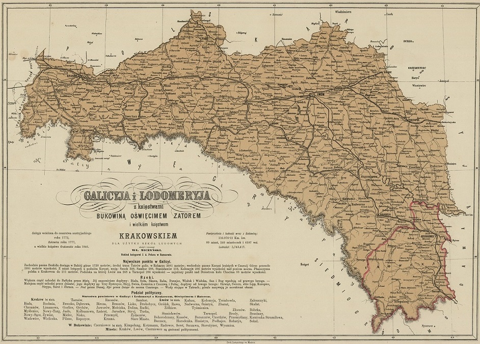
Zoom viewer: Polona
Mapa Królestwa Galicyi do nauki z poglądu (1874)
Antoni Latinik, Kraków
Map of the Kingdom of Galicia to learn by sight: for elementary schools: dedicated to His Excellency Count Agenor Gołuchowski k.k. Governor in memory of many years of effective and dedicated work for the good of the country
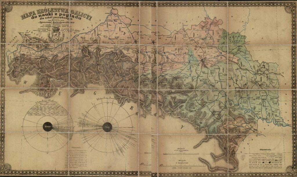
Source: Mapa Królestwa Galicyi do nauki z poglądu : dla szkół początkowych
Mapa statystyczna Galicji i Bukowiny obejmująca stosunki ogólne polityczno-administracyjne, komunikacyjne, rolnicze a poszczególnie przemysł krajowy (1878)
Maksymilian Bodyński, Michałowski, Jarosław. Vienna
Statistical Map of Galicia and Bukovina. Highly detailed statistical map of Galicia and Bukovina, on 10 sheets, in Polish and German languages, from 1878.
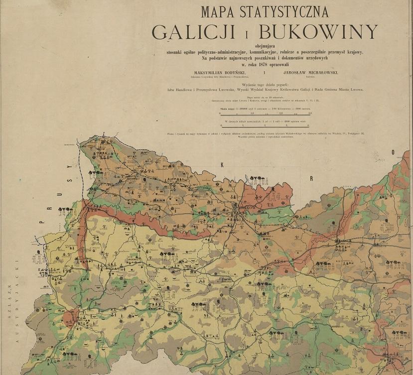
Source: Mapa statystyczna Galicji i Bukowiny
Zoomable view: Gesher Galicia
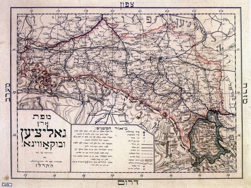
Map of Galicia and Bukovina in Hebrew (1878)
From “Illustrierter Führer durch die Bukowina,” published by Mandelbaum Verlag
General Post- und Strassenkarte von Galizien und Lodomerien mit Auschwitz, Zator und Krakau so wie des Kronlandes Bukowina (1893)
R.A. Schulz
General Post and Road Map of Galicia and Lodomeria with Auschwitz, Zator and Krakow as well as the Crownland Bukovina. This map contains a table of population statistics from the 1890 census. Railways are clearly marked.
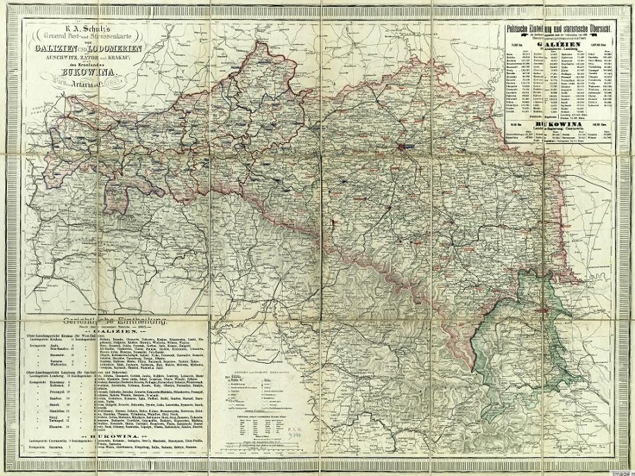
Source: RCIN
Mapa ścienna Królestwa Galicyi i Lodomeryi z Wielkiem Księstwem Krakowskiem z Księstw: Oświęcimskiem i Zatorskiem (1894)
Stanisław Majerski, Lwów
Wall Map of the Kingdom of Galicia and Lodomeria with the Grand Duchy of Krakow with the Duchies: Auschwitz and Zatorsk.
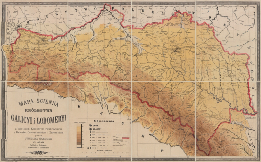
Zoomer view: Polona
Karta klimatyczna Galicyi (1899)
Climate Map of Galicia
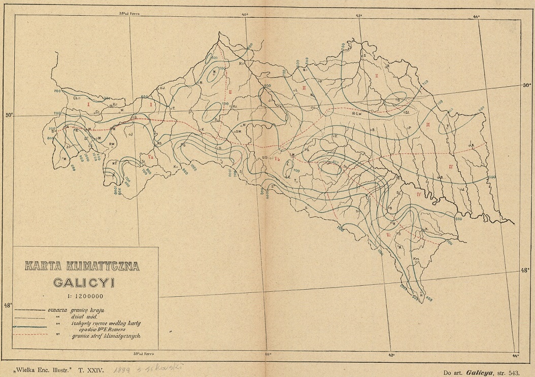
Zoomer view: Polona
Mapa Galicyi (1900)
Map of Galicia. Shows Polish single-mandate district, Ruthenian single-mandate district with the exclusion of Poles, Polish and Ruthenian two-mandate district, Ruthenian cadastral district, and Polish cadastral district.
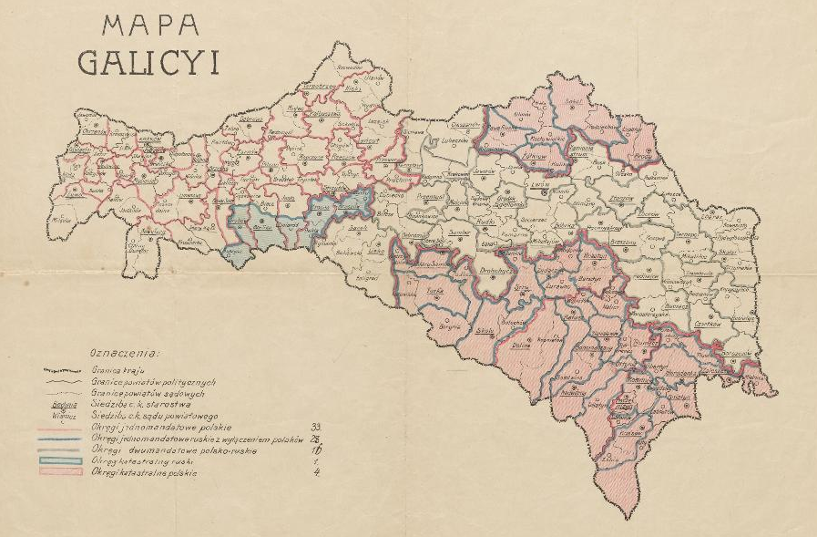
Source: Digital Library of University of Wroclaw
General Post- und Strassenkarte von Galizien und Lodomerien mit Auschwitz, Zator und Krakau (1900)
R. A. Schulz, Vienna
General Post and Road Map of Galicia and Lodomeria with Auschwitz, Zator and Krakow as well as the Crownland Bukovina
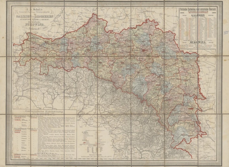
Zoom viewer: Polona
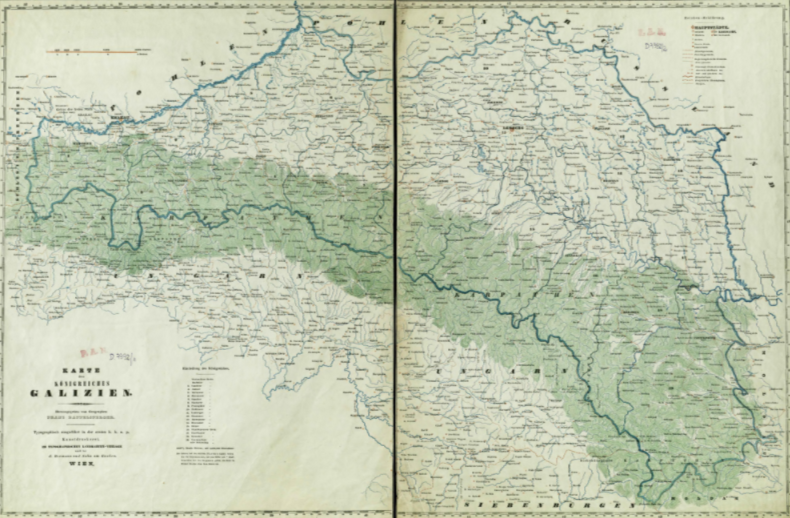
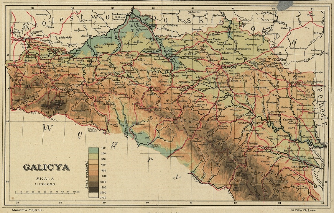
Mapa ścienna Królestwa Galicyi i Lodomeryi z Wielkiem Księstwem Krakowskiem z Księstw: Oświęcimskiem i Zatorskiem (c. 1910)
Stanisław Majerski, Lwów
Wall Map of the Kingdom of Galicia and Lodomeria with the Grand Duchy of Krakow and the Duchies: Auschwitz and Zator. Shows towns, elevation, and major geographic landmarks.
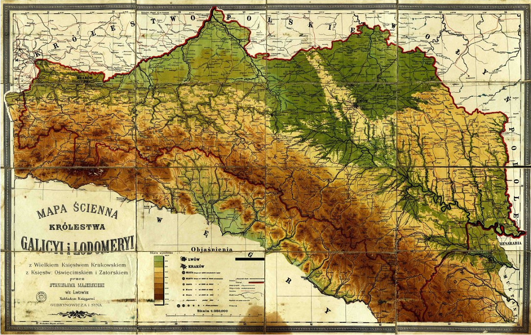
Source: Gesher Galicia
Galicja Map Językówa (1911)
Wincenty Choroszewski, Lwów
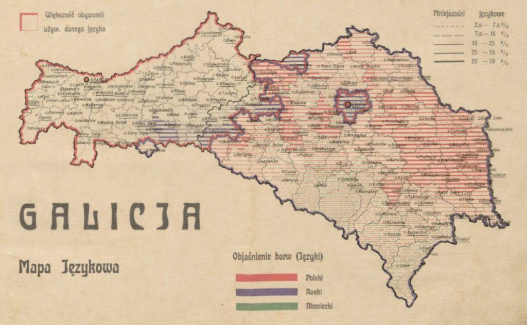
Source: Mapa językowa i wyznaniowa Galicji
Mapa Galicyi i Bukowiny z Wielkim Księstwem Krakowskiem (1915)
Stanisław Majerski, Lwów
Map of Galicia and Bukovina with the Grand Duchy of Krakow
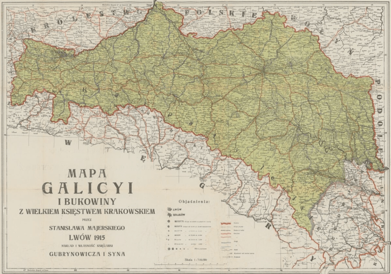
Source: Mapa Galicyi i Bukowiny z Wielkim Księstwem Krakowskiem
Galicya (1918)
Stanisław Majerski
Zoomer view: Polona
_F.I._Marie.jpg)
_C.F._Weiland.jpg)
Was Rudenka a city inGalicia?
If you mean this village (https://en.wikipedia.org/wiki/Rudenka) then yes, I believe so.
Je suis impressionnée par vos recherches, je ne pensais pas trouver autant de documentation sur un seul site, bravo!
Merci beaucoup 🙂
Amazing material….
I am looking for Popovitsi or Popowce who existed in 1911.
Hola. Mi abuelo Stanislaw Iwanicki nació en Ostrow Galtzia en 1904. Podrian orientarme donde encontrar su partida de nacimiento? Espero con ansiedad quien me pueda ayudar. Gracias
Rodzina Iwanickich mieszkala również w Milatynie Nowym, 40 km na wschód od Lwowa. Ja urodziłam się już w wolnej Polsce w 1961, w Lubinie na Dolnym Śląsku, gdzie zamieszkała moja Rodzina po wojnie. W Lubinie był lekarz- nazywał się Iwanicki.
May I suggest adding to your great list two more excellent historical maps of Galicia available via mapywig.org :
– the Liesganig map (1790/1824): “KOENIGREICH GALIZIEN UND LODOMERIEN HERAUSGEGEBEN IM JAHRE 1790 VON LIESGANIG. NACH DEN VORZÜGLICHSTEN NEUERN HÜLFSQUELLEN VERMEHRT und VERBESSERT VON DEM K.K. OEST. GENERALQUARTIERMEISTERSTABE IM JAHRE 1824” – the visual index of which is available via Mapster at http://igrek.amzp.pl/mapindex.php?cat=KGL288
– the Kummersberg map (1855): “Administrativ-Karte von den KÖNIGREICHEN GALIZIEN UND LODOMERIEN mit dem Grossherzogthume KRAKAU und den HERZOGTHÜMERN AUSCHWITZ, ZATOR UND BUKOWINA in 60 Blättern”, C.R. von Kummersberg, 1855, 1:115 000. Wien, Verlag u Eigenthum von Artaria – the visual index of which is available via Mapster at http://igrek.amzp.pl/mapindex.php?cat=AKKGL115
Thanks
-EdM
Thanks for the tip! Will add it when I have a chance
Ed,
Try looking here: http://easteurotopo.org/images/regional%20maps%20of%20eastern%20europe/Galicia/Liesganig_94.html
The sections have been assembled into one map.
Regards.
Hap Ponedel
easteurotopo.org
I am looking for this village -Prewusipl- it was where my great grandparents came from, back in 1903, when they chose to settle in Saskatchewan, Canada.
The information I have is that it was a village, located in the province of Galatia, which at time was part of the Austrian Empire (today part of Ukraine, I believe). Any information you can share would be greatly appreciated. Thank you in advance.
Olivia,
I am looking for your town, but the spelling is not working. I will look around Galicia more.
If you have any documents that show other spellings it would be helpful to have those alternate spellings. Perhaps you can share your ancestors names. Sometimes a search will reveal town names.
Hap Ponedel
easteurotopo.org
My grandparents list their birthplace as Stubianko-Galicya, Austria. He was a Slizak, his parents were Grzegoz Slizak, Rozalia Sekowska. My grandmother was Steczynska. my great grandmother, Czerwiecka. I would like to follow my grandparents path, in reverse of course but do not speak Polish or Ukrainian as they did and am unable to find any information on Stubianko online. Any help would be greatly appreciated
Hi Grant, I suggest you join this group and ask here: https://www.facebook.com/groups/644292589109006/
I am wondering if anybody can locate the village “Dobrowovy” near “Lwow”. My grandfather was from there
I’m looking for a village or city of Antoniwka (possible misspelled variation, lost in translation) in the state of Galicia?
It could be this village in former Galicia, now in Poland: https://en.wikipedia.org/wiki/Antoni%C3%B3wka,_Stalowa_Wola_County
Hello, Sheldon! Are you still looking for Antonivka? I am Mykhaylo, from Galicia, now called Halychyna, and there are even 2 villages of Antonivka here, one in the Sryi District, and another in the Zhydachiv District, both in the Lviv Region in the historic province of Halychyna of Ukraine. Which one suits you more? Regards, Mykhaylo (you may Email me directly at:MykhayloKlen@gmail.com)
I’m looking for the town of STRONIOWICE (1914′ name of the town) in Galicia, where my grandfather
seems has dead in a battle against Russian Army on october 20,, 1914.
I’m asking you if there is/was, in Galiacia, a town so called and if in that zone there have been any battle
in those period.
I would like to know the location of the town and if there is a war cemetery…
Maybe STRONIOWICE is not in Poland, now…
Thank you for your kindness
Giovanni Concer
Cles, Italy 07/04/2020
It seems to be this town, which is now in Ukraine. The Ukrainian name is Storonevychi (Стороневичі). It is near Staryi Sambir, near the border with Poland.
Ukrainian: https://uk.wikipedia.org/wiki/%D0%A1%D1%82%D0%BE%D1%80%D0%BE%D0%BD%D0%B5%D0%B2%D0%B8%D1%87%D1%96
Polish: https://pl.wikipedia.org/wiki/Stroniowice
I have a Tomasz and Julian Golub / Golab from Stroniowice, too. Tomasz emigrated to Winnipeg, Manitoba, Canada in 1926. If you come across them please let me know. Cheers!
Giovanni,
I believe your town may be in Bohemia, the Czech republic. There is a Strunkovice nad Volynkou, and also a Strunkovice nad Blanici. Both are south of Prag. The spelling you gave produced these results in a search. I have not found this town in Galicia yet.
Hap Ponedel
My great grandparents, Gregor and Nastia Sirko migrated to Pittsburgh, PA in between 1899-1902. I found official documentation from U.S.A. stating they came from “Syniowo”, Austria-Hungary Empire. Ukrainian language is documented as their native language, however, I have found census reports from later years (1920-1950) listing Poland as former country homeland. In my search of this village and I cannot find anywhere with this exact spelling (not surprised), however, I found three villages that sound similar to “Syniowo” and are all three villages are spelled the same: Sieniawa. Two in southeast Poland and one in Ukraine.
Any thoughts? Leads? Or ideas as to how to determining which village it was?
1.) Sieniawa, Poland – a village off the San River, just north of Jaroslaw, Poland. Current population: 2,100.
https://en.wikipedia.org/wiki/Sieniawa
2.) Sieniawa, Poland – an even smaller village in southeast Poland just 4 km east of Rymanów, Poland. Current population: 1,000.
https://en.wikipedia.org/wiki/Sieniawa,_Krosno_County
3.) Sieniawa (or Synyava, Syniava, or Stara Synyavka), Ukraine – a small village 180 km east of Ternopil, Ukraine. Current population: 5,500. I have only found one piece of evidence (a map) linking this village to former Austria-Hungary Empire, Galacia.
Map: http://easteurotopo.org/images/regional%20maps%20of%20eastern%20europe/Galicia/Liesganig_94.html
https://en.wikipedia.org/wiki/Stara_Syniava
Hello,
I have an ancestors that foght in 1914 in Galizia. He mentioned in a letter that he was wounded and carried out to the city of “Luiz” there.
Please, can you tell me the right spell of the name of this city? Because I supposed it’s wrong written.
Thank you.
My grandfather’s mother’s family was from what was called Wilkie Oczy, or pronounces Villkutch in Yiddish. They immigrated to Pittsburgh in the early part of the last century.
The town in Galicia is near Lviv, or Lemberg in Yiddish, current day Ukraine, then Poland Galicia.
Does the name Bruckenthal mean anything to you?
“Lemberg” in German from the Astro-Hungarian Empire to which it belonged and coincidentally Yiddish a form of pigeon German widely spoken in that area at the time.
Bruckenthal a compound German word literally meaning Valley of the Bridges
My paternal grandparents emigrated to Manitoba, Canada. Both were born in SKALA, AUSTRIA which I understand is on the eastern border of former GALICIA (Galicyi) now in Ukraine. My grandfather (surname Maydanuk) was born 13th January 1887 and emigrated to Canada in 1903 (aged 16) presumably with his family; my grandmother (maiden name Syrovetanyk) was born 18th August 1888 and emigrated to Canada in 1905 (aged 17) again presumably with her family. I am unsure of the exact spelling of their respective surnames – I would be interested if anyone could advise if they are typical names of the area? Also can anyone advise how to access birth certificates etc ?; if they are readily available as I would very much like to trace their siblings/parents if at all possible? Most grateful to anyone who can advise. Very happy to have discovered such an interesting site.
My Father was born in Proskurov now Kmelnitzki Russia in 1884. I need to know anything I can about his life. He never spoke about what he went through. Do not know if i have relatives, cousins in Russia or in South America. Our last name was Uroda.
My father, Demstiuk, was born in Zhelekhiv, Galicia. I was wondering where it is on the map and any information about his ancestors. His parents farmed near there.
fao Germán
It could be a town of “Luck” (in Polish), or “Lutzk” / “Luzk” (in German-speaking documents), north-west / west Ukraine.
Regards,
n.
Could you please send me an idea on the location of the town of Hludno. It was part of Galicia in Austria in the Carpathian mt. My grand parents came from there 1908. I understand it was partitioned off to Poland in 1918.
https://en.wikipedia.org/wiki/H%C5%82udno
I am curious about the co-ordinate systems many 18th- and 19th-century maps use — in particular, degrees of longitude east/west. I take an interest in Czernowitz (Chernivtsi) because my paternal grandmother was born there. Many of the maps on your list show Czernowitz at 43° 39′ East longitude. I have an 1878 map (not on your list) titled “MAPAT ERETZ GALITSIEN VBUKOVINA” that locates it at 23° 37′ East longitude. Modern-day Google Maps puts it at 25° 56′ East longitude. Presumably the city hasn’t physically moved. So… What’s going on?
Do you, or anyone, have any information about a town or village in western Galicia called тисова? I was born there but fled with my family in 1943-1944.
Hello Bohdar,
If you are sure it was spelled exactly Тисова, with a Т, then there’s only one of them.
See:
However, if you think it could have been spelled Цисова, with a Ц, then there are several possibilities.
See:
Note that Тисова is an alternative spelling of one of the villages called Цисова.
Hmm…
I was trying to send you links to pages on Ukrainian Wikipedia, but apparently links are deleted.
Sorry.
Hello.
I am a filmmaking professor that has long roots through my wife in Hungary. I was wondering if you have ever thought of making a film about this region to capture the culture of the area before it is totally lost in the next generations. I am interested in all parts of the culture — dance, song, stories, language, history. This is a fascinating area. let me know. plewis14@gsu.edu
Thanks. PHIL LEWIS
Dear Person,
My name is Raegan Graziani. I am researching my Jewish ancestry.
My great grandfather, Stanislaw Federowicz, was born in 1863 in Stryjowka, Zbaras, Galicia Ukraine.
His parents’ names were Pawel Fedorowicz and Antonina (Dobrowolska) Fedorowicz.
Stanislaw immigrated to the United States before World War l. He was in the United States before 1914 when they had their first child. He was a Tailor in the United States
Thank you so much for your kind attention and help.
I’ve been looking for my grandmother, Mary Mergda (Sp.?) who was born in “Galicia” in 1898 (August 25? 15?), but came alone to Pittsburgh, PA. area (Canonsburg?) in 1913 at age 15. She married within the year to Samuel Okal. If you know anything about where my grandmother was actually born, and where this grandfather I never knew was from, I’d appreciate so much any direction…
I haven’t heard about my inquiry (above) yet.
Also, my grandmother (Mary Mergda) always said she was from Austria, but I’m sure the borders have shifted now.
This is a wonderful resource. I am looking for the town in Galicia that my great grandparents lived in before emigrating to Canada in 1889. It was called Brigidau. Also, my great grandmother was born in Ugartsberg, Galicia. Where is that? I believe Galicia was referred to as Galizien Kroenlande. Is that correct? Thank you in advance for your response.
Ukrainian wikipedia writes: Brigidau (Polish: Brygidyn) is a German agricultural colony that existed in the modern village of Lanivka, Stryj District, Lviv Oblast. The colony was founded in 1783. One of the many settlements created during the colonization program begun by the Austrian Emperor Joseph II in 1782.
A Question: Does it make sense for a person who migrated from Rymonow in the mid 1910’s to think of himself as both Polish and Austrian? His documents listed both as well as Galicia.
Yes it does make sense. Ethnically this person was probably Polish (Roman Catholic, Polish-speaker), but he lived in the Austrian Empire and thus was probably loyal to the Emperor.
I would like to learn about Lemko life in the city of Sanok Poland, my family, Oklejewicz and Niemishnik lived there.
My grandparents came separately to NYC from Hungary in the late 1880 . From a tiny village near Budapest.called gellnitch probably not spelled this way but pronounced gell nitz. My grandfather was a Tailor in the old country and his name was immediately changed from Alexander vrabley to waraby…my grand mother was ottelie schwartner.
Сьогодні випадково натрапив на ваш ресурс, який мене дуже зацікавив. Я народився підчас Другої світової війни в містечку Делятин, що в передгір’ї Карпат. Від 1961 р. мешкаю у Львові, але моя “мала батьківщина” назавжди в моєму серці і від тривалого часу пошукую будь-які інформації про колишніх делятинців і їх нащадків, історичні факти, пов’язані з цією місцевістю, а також фотографії мешканців і всіляких об’єктів на цій території. Все це потрібне для написання правдивої історії про Делятин у фактах і іменах. В цьому містечку крім українців і поляків проживало чимало євреїв, кількість яких сягала в певний період більше 40%, але майже всі вони були знищені в часи голокосту. Відізвіться делятинці всього світу!
Was Stashow part of Galicia?
I have been looking for Valinien. Ancestor Anton Lemke and family fled to Valinien to the east around the 1880s due to a Polish uprising. Same for Johann Hauptfeisch & family who fled from the same village in either Silesia or Galicia or Subcarpathian Poland. I believe they live in Galicia and in the 1880s escapes to Valinien to raise their families which ended up with Johann Hauptfeisch marrying Ida Lemke (Lamke) around 1887 to 1888. Can you help? I have spent a week searching for Valinien and would love to know what village they fled to survive. Anton Lemke who was blind escaped with a rope around his neck.
Hello, we have a ship manifest from Ellis Island (1905) listing family as coming from “Dobzina” and ethnicity as “Austrian-Polish.” I’m trying to figure out if that is most likely what is today Dobšiná, Slovakia or somewhere else. Any insights would be greatly appreciated! Thank you.